
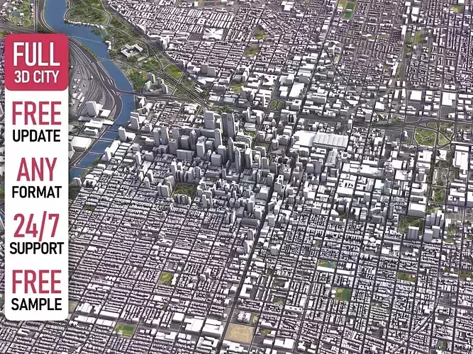
Philadelphia Low-poly 3D model
TRY BEFORE YOU BUY Message us to get a FREE sample scene of this product! (please specify file format) Download an overview sample - www.each.city/sample WHAT IS INCLUDED DETAILS Scene size: Entire area — refer to promo images for scene extents Units: Meters — real-world scale Updated: June 2024 — want the latest? Ask before you pay KEY BENEFITS 24/7 customer support — reach out to us anytime for pre-sale inquiries or after-sale support Extensive file format support — 3ds Max (native), fbx, obj, dae, c4d, skp, 3dm, rvt, blend, etc., or ask for more before payment Georeferencing — either Web Mercator, Transverse Mercator, or original CRS. If a specific CRS is essential, ask before you pay Any scene size or crop to an area-of-interest — for best performance and format compatibility, inquire before paying Buildings, land-use areas, roads and railways split by type — layers / named objects Detailed landmarks with regular updates and improvements — available annually or upon pre-purchase inquiry Realistic and detailed surface texture — 1-meter resolution satellite imagery Flat surface, easy for detailing and geometry edits — topography terrain available at an additional cost. Message us for a quote Realistic low-poly vegetation — individual trees in max and fbx formats, additional formats upon request before you pay Product is ready to render out-of-the-box — 3ds Max + Corona Render PRESENTATION IMAGES 4K high-resolution renders — refer to images for level of detail and scene size Produced in 3ds Max — other software requires its rendering settings MATERIALS Trees, vegetation, land-use and airport surface with the textures assigned Buildings are UV mapped, split by material IDs, and no textures assigned FREE UPDATE Our 3D City Models are regularly updated, and you will receive the latest version as soon as it's released For manual updates to the latest data, please contact us before making a purchase (additional fees may apply) CUSTOMIZE & SAVE TERMS & CONDITIONS For fast turnaround, flexible pricing, and custom discounts, contact us instead of purchasing directly Fully customizable model based on the options listed below SCENE SIZE Full city extents up to 100 x 100 km — or crop to an area of interest for better format compability and scene performance Extended area up to 1000 x 1000 km — or any size options or slice to tiles DATA AUTHENTICITY 100% real buildings coverage — unlike other sellers, we don’t use AI generated building footprints Combining multiple sources — you may povide us with any dataset to include in the model GEOREFERENCING Coordinate Reference Systems (CRS) - available options Web Mercator — specified by true scale latitude Transverse Mercator — defined by central meridian Original CRS — local or optimal for this area Geolocation — allows you to precisely position 3D content at any specified latitude and longitude TOPOGRAPHY TERRAIN Up to 1-meter accuracy digital terrain model (DTM) — quad mesh Multiple terrain LODs — triangle mesh optimized for the best polycount / details balance Buildings and roads placed on the optimized terrain Separate land surface and water bodies High-resolution satellite or surface texture — up to 0.2 meter accuracy Contour lines — 3D splines, up to 1-meter interval MANUAL MODELING Buildings and structures — LOD2 and LOD3 Elevated highways — interchanges, bridges and flyovers TEXTURING High-resolution surface texture — satellite image up to 0.2 meter accuracy Streets and roads with markings texture — UV mapped along the center line Procedural textures assigned to all buildings — LOD1 only Realistic textures on individual buildings — LOD2 and LOD3 TREES & FORESTS Individual trees — real trees from OSM data Procedural forests — based on distribution areas, convertible to individual trees OTHER EXTRAS Individual buildings and streets — separate objects with address and/or name
Digital Delivery
This is a digital product. No physical item will be manufactured, packaged, or shipped. Once your payment is confirmed, your files will be available to download.
A download link is emailed to you right after checkout, and the same files stay available from your order confirmation page — no waiting on the mail.
Before You Buy
- Exact file formats and what's included are listed in the product description above — check it matches the software or hardware you plan to use.
- Preview images illustrate the design; on-screen colors and final output can vary slightly depending on your device and software settings.
- Digital files are non-refundable once downloaded, since a download can't be "returned" the way a physical item can — see our Return Policy for details.
Usage Rights
Purchased files are for your own use under the license tier selected at checkout — they may not be resold, redistributed, or re-uploaded as a standalone digital product. Full terms are in our Terms of Service.
Customer Reviews
No reviews yet. Be the first to share your experience!